
Make a donation
Gear up for your next adventure:
As an Amazon Associate, this site earns from qualifying purchases at no extra cost to you.
Asmara topographic map
Click on the map to display elevation.
Make a donation
Gear up for your next adventure:
As an Amazon Associate, this site earns from qualifying purchases at no extra cost to you.
Asmara
Asmara (/æsˈmɑːrə/ əs-MAHR-ə), or Asmera, is the capital and most populous city of Eritrea, in the country's Central Region. It sits at an elevation of 2,325 metres (7,628 ft), making it the sixth highest capital in the world by altitude and the second highest capital in Africa. The city is located at the tip of an escarpment that is both the northwestern edge of the Eritrean Highlands and the Great Rift Valley in neighbouring Ethiopia. In 2017, the city was declared as a UNESCO World Heritage Site for its well-preserved modernist architecture. According to local traditions, the city was founded after four separate villages unified to live together peacefully after long periods of conflict. Asmara existed as a major settlement for over half a millennium and enjoyed some importance as it stood on the trade route to Massawa. Asmara first rose to prominence during the 20th century, when it became capital of Italian Eritrea. Under Italian rule the city of Asmara experienced rapid urbanization and modernization, to the point that was called Piccola Roma (Little Rome).
Make a donation
Gear up for your next adventure:
As an Amazon Associate, this site earns from qualifying purchases at no extra cost to you.
About this map
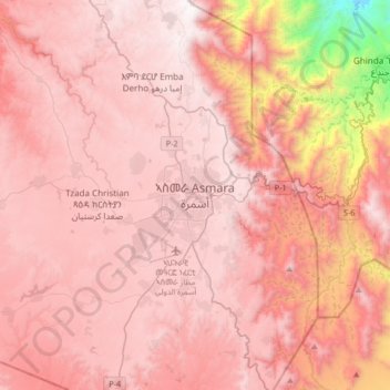
Name: Asmara topographic map, elevation, terrain.
Location: Asmara, Maekel Region, Eritrea (15.17897 38.77268 15.49897 39.09268)
Average elevation: 6,683 ft
Minimum elevation: 1,850 ft
Maximum elevation: 8,428 ft
Make a donation
Gear up for your next adventure:
As an Amazon Associate, this site earns from qualifying purchases at no extra cost to you.