
Make a donation
Gear up for your next adventure:
As an Amazon Associate, this site earns from qualifying purchases at no extra cost to you.
Abadín topographic map
Click on the map to display elevation.
Make a donation
Gear up for your next adventure:
As an Amazon Associate, this site earns from qualifying purchases at no extra cost to you.
Abadín
Abadín is situated in the north-east of Terra Chá. The municipality is crossed by the Serra do Xistral, the Cordal de Neda, and the rivers Labrada and Abadín. The mean elevation is of 500 m, and the highest point is Lombo Pequeno at 1015 m.
Make a donation
Gear up for your next adventure:
As an Amazon Associate, this site earns from qualifying purchases at no extra cost to you.
About this map
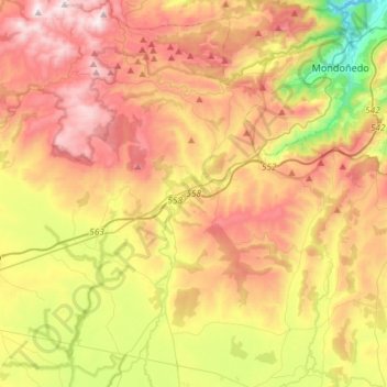
Name: Abadín topographic map, elevation, terrain.
Location: Abadín, Terra Chá, Lugo, Galicia, Spain (43.25371 -7.59507 43.46663 -7.37759)
Average elevation: 1,795 ft
Minimum elevation: 194 ft
Maximum elevation: 3,376 ft
Make a donation
Gear up for your next adventure:
As an Amazon Associate, this site earns from qualifying purchases at no extra cost to you.
Other topographic maps
Click on a map to view its topography, its elevation and its terrain.
Make a donation
Gear up for your next adventure:
As an Amazon Associate, this site earns from qualifying purchases at no extra cost to you.