
Thank you for supporting this site ❤️
Make a donation
Make a donation
Gear up for your next adventure:
As an Amazon Associate, this site earns from qualifying purchases at no extra cost to you.
Hennaya topographic map
Click on the map to display elevation.
Thank you for supporting this site ❤️
Make a donation
Make a donation
Gear up for your next adventure:
As an Amazon Associate, this site earns from qualifying purchases at no extra cost to you.
About this map
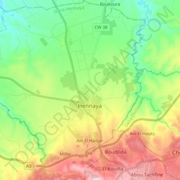
Name: Hennaya topographic map, elevation, terrain.
Location: Hennaya, Hennaya District, Tilimsen, 13009, Algeria (34.90316 -1.45398 35.01801 -1.32305)
Average elevation: 1,322 ft
Minimum elevation: 650 ft
Maximum elevation: 2,461 ft
Thank you for supporting this site ❤️
Make a donation
Make a donation
Gear up for your next adventure:
As an Amazon Associate, this site earns from qualifying purchases at no extra cost to you.