
Make a donation
Gear up for your next adventure:
As an Amazon Associate, this site earns from qualifying purchases at no extra cost to you.
Zeddam topographic map
Click on the map to display elevation.
Make a donation
Gear up for your next adventure:
As an Amazon Associate, this site earns from qualifying purchases at no extra cost to you.
Zeddam
Die Motte Montferland wurde als Höhenburg auf einem Hügel von 66,8 m Höhe über dem Meeresspiegel um 1000 gebaut. Davon wurden mindestens 7 m künstlich für ein Plateau aufgeschüttet. Erste Besitzerin der noch Uplade genannten Burg war Gräfin Adela von Hamaland zusammen mit ihrem Gemahl Balderik. Im Streit um das Erbe ihres Vaters Wichmann von Hamaland soll sie ihre Schwester, die Äbtissin Luitgard, vergiftet haben, auch um den nahen Eltenberg in Besitz zu bekommen (so berichtet der Mönch Alpert von Metz). Im Jahr 1016 wurde die Motte durch ihre Feinde eingenommen und dem Erdboden gleichgemacht.
Make a donation
Gear up for your next adventure:
As an Amazon Associate, this site earns from qualifying purchases at no extra cost to you.
About this map
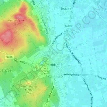
Name: Zeddam topographic map, elevation, terrain.
Location: Zeddam, Montferland, Geldern, Niederlande (51.89082 6.21793 51.92362 6.28474)
Average elevation: 98 ft
Minimum elevation: 36 ft
Maximum elevation: 282 ft
Make a donation
Gear up for your next adventure:
As an Amazon Associate, this site earns from qualifying purchases at no extra cost to you.
Other topographic maps
Click on a map to view its topography, its elevation and its terrain.
Make a donation
Gear up for your next adventure:
As an Amazon Associate, this site earns from qualifying purchases at no extra cost to you.
Make a donation
Gear up for your next adventure:
As an Amazon Associate, this site earns from qualifying purchases at no extra cost to you.
Make a donation
Gear up for your next adventure:
As an Amazon Associate, this site earns from qualifying purchases at no extra cost to you.