
Thank you for supporting this site ❤️
Make a donation
Make a donation
Gear up for your next adventure:
As an Amazon Associate, this site earns from qualifying purchases at no extra cost to you.
Röhrmoos topographic map
Click on the map to display elevation.
Thank you for supporting this site ❤️
Make a donation
Make a donation
Gear up for your next adventure:
As an Amazon Associate, this site earns from qualifying purchases at no extra cost to you.
About this map
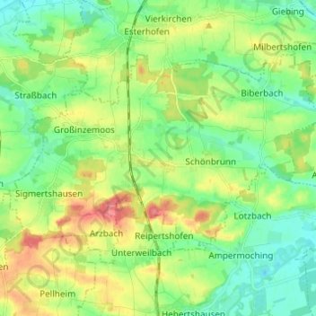
Name: Röhrmoos topographic map, elevation, terrain.
Location: Röhrmoos, Landkreis Dachau, Bavaria, 85244, Germany (48.30268 11.39791 48.35685 11.52042)
Average elevation: 1,604 ft
Minimum elevation: 1,516 ft
Maximum elevation: 1,762 ft
Thank you for supporting this site ❤️
Make a donation
Make a donation
Gear up for your next adventure:
As an Amazon Associate, this site earns from qualifying purchases at no extra cost to you.
Other topographic maps
Click on a map to view its topography, its elevation and its terrain.