Geolocate

Margaret topographic map

Click on the map to display elevation.

About this map

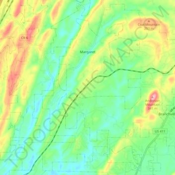
Name: Margaret topographic map, elevation, terrain.

Location: Margaret, St. Clair County, Alabama, 35112, United States (33.63365 -86.50975 33.70704 -86.41998)

Average elevation: 781 ft

Minimum elevation: 607 ft

Maximum elevation: 1,102 ft

St. Clair County trails, hiking, mountain biking, running and outdoor activities

Other topographic maps

Click on a map to view its topography, its elevation and its terrain.

Cook Springs

United States > Alabama > St. Clair County

Average elevation: 728 ft

Ragland

United States > Alabama > St. Clair County

Average elevation: 607 ft

Parsons

United States > Alabama > St. Clair County > Moody > Parsons

Average elevation: 702 ft

Cropwell

United States > Alabama > St. Clair County > Pell City

Average elevation: 509 ft

Gear up for your next adventure:

🚗GPS Dash Cams - Record your scenic drives through mountain passes and canyons
🧣Hiking Neck Gaiter - Multi‑use neck protection for outdoor weather
🪑Portable Camp Table - Compact table for campsite meals
🧺Microfiber Travel Towels - Compact and fast-drying towels for trail use
🧭Orienteering Set - Complete compass and map reading kit

As an Amazon Associate, this site earns from qualifying purchases at no extra cost to you.