
Make a donation
Gear up for your next adventure:
As an Amazon Associate, this site earns from qualifying purchases at no extra cost to you.
Aldeneik topographic map
Click on the map to display elevation.
Make a donation
Gear up for your next adventure:
As an Amazon Associate, this site earns from qualifying purchases at no extra cost to you.
About this map
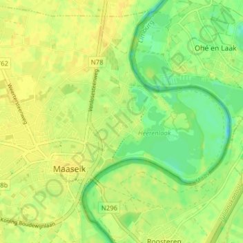
Name: Aldeneik topographic map, elevation, terrain.
Location: Aldeneik, Maaseik, Limburg, 3680, België (51.08252 5.78536 51.12252 5.82536)
Average elevation: 95 ft
Minimum elevation: 52 ft
Maximum elevation: 115 ft
Make a donation
Gear up for your next adventure:
As an Amazon Associate, this site earns from qualifying purchases at no extra cost to you.
Other topographic maps
Click on a map to view its topography, its elevation and its terrain.
Opoeteren
België > Limburg > Maaseik > Maaseik
Opoeteren ligt in het dal van de Bosbeek, die zich insnijdt in het Kempens Plateau. Vooral de zuidoostelijke flank is erg steil en de hoogte loopt op tot 75 meter. Ten oosten van Opoeteren heeft grindwinning plaatsgevonden en is een plassengebied ontstaan, het Bergerven, dat samen met de aangrenzende bossen,…
Average elevation: 220 ft