Geolocate

Pelly topographic map

Click on the map to display elevation.

About this map

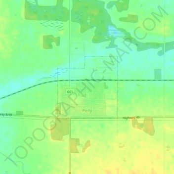
Name: Pelly topographic map, elevation, terrain.

Location: Pelly, Division No. 9, Saskatchewan, Canada (51.85196 -101.93485 51.86155 -101.91971)

Average elevation: 1,545 ft

Minimum elevation: 1,506 ft

Maximum elevation: 1,581 ft

Other topographic maps

Click on a map to view its topography, its elevation and its terrain.

Swan Plain

Canada > Saskatchewan > Division No. 9 > Clayton No. 333

Average elevation: 1,762 ft

Insinger

Canada > Saskatchewan > Division No. 9 > Insinger No. 275

Average elevation: 1,768 ft

Gear up for your next adventure:

🔥Camping Stove - Portable stove for camping and backcountry cooking
🪶Trail Camera - Capture wildlife on your hikes
🛏️Cold Weather Sleeping Bag - Warm sleeping bag for cold conditions
👓Polarized Sunglasses - Outdoor sunglasses for glare reduction
🛡️Bear Spray Outdoor - Protection in bear country hikes

As an Amazon Associate, this site earns from qualifying purchases at no extra cost to you.