Geolocate

Guayaquil topographic map

Click on the map to display elevation.

About this map

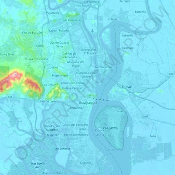
Name: Guayaquil topographic map, elevation, terrain.

Location: Guayaquil, Guayas, Ecuador (-2.28757 -79.95912 -2.05336 -79.85635)

Average elevation: 56 ft

Minimum elevation: -20 ft

Maximum elevation: 1,506 ft

Other topographic maps

Click on a map to view its topography, its elevation and its terrain.

Puerto del Morro

Ecuador > Guayas > Guayaquil > Morro

Average elevation: 20 ft

Chongón

Ecuador > Guayas > Guayaquil

Average elevation: 95 ft

Villa España 2

Ecuador > Guayas > Guayaquil > Guayaquil

Average elevation: 36 ft

La Vielocia

Ecuador > Guayas > Guayaquil > Guayaquil

Average elevation: 135 ft

Puerto Hondo

Ecuador > Guayas > Guayaquil > Guayaquil

Average elevation: 171 ft

Gear up for your next adventure:

🥇GPS Hiking Watch - Multi‑sport GPS watch with navigation and trail tracking
🎒Outdoor Daypacks - Lightweight backpacks designed for carrying maps and essential gear
🌎3D Topographic Globes - Raised relief globes for a tactile understanding of geography
🎁Geography Themed Gifts - Unique gift ideas for map lovers and geography enthusiasts
🔋Solar Power Banks - Keep your GPS and phone charged in remote wilderness areas

As an Amazon Associate, this site earns from qualifying purchases at no extra cost to you.