Make a donation
Gear up for your next adventure:
As an Amazon Associate, this site earns from qualifying purchases at no extra cost to you.
Lower Dresden topographic map
Click on the map to display elevation.
Make a donation
Gear up for your next adventure:
As an Amazon Associate, this site earns from qualifying purchases at no extra cost to you.
About this map
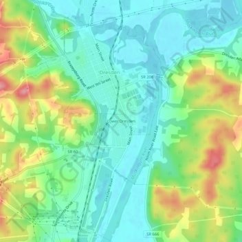
Name: Lower Dresden topographic map, elevation, terrain.
Location: Lower Dresden, Muskingum County, Ohio, 43821, United States (40.09340 -82.02819 40.13340 -81.98819)
Average elevation: 814 ft
Minimum elevation: 692 ft
Maximum elevation: 1,060 ft
Muskingum County trails, hiking, mountain biking, running and outdoor activities
Make a donation
Gear up for your next adventure:
As an Amazon Associate, this site earns from qualifying purchases at no extra cost to you.
Other topographic maps
Click on a map to view its topography, its elevation and its terrain.
Make a donation
Gear up for your next adventure:
As an Amazon Associate, this site earns from qualifying purchases at no extra cost to you.
Make a donation
Gear up for your next adventure:
As an Amazon Associate, this site earns from qualifying purchases at no extra cost to you.
Dresden
United States > Ohio > Muskingum County
The median elevation of Dresden is 741 feet (226 m).
Average elevation: 771 ft
