
Kubwa topographic map
Click on the map to display elevation.
About this map
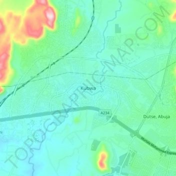
Name: Kubwa topographic map, elevation, terrain.
Location: Kubwa, Municipal Area Council, Federal Capital Territory, Nigeria (9.11268 7.30108 9.19268 7.38108)
Average elevation: 1,506 ft
Minimum elevation: 1,266 ft
Maximum elevation: 2,470 ft
Other topographic maps
Click on a map to view its topography, its elevation and its terrain.
Gwarinpa
Nigeria > Federal Capital Territory > Municipal Area Council > Gwarinpa
Average elevation: 1,545 ft
Central Business District
Nigeria > Federal Capital Territory > Municipal Area Council
Average elevation: 1,621 ft
Maitama
Nigeria > Federal Capital Territory > Municipal Area Council > Abuja
Average elevation: 1,680 ft
Katampe
Nigeria > Federal Capital Territory > Municipal Area Council > Abuja
Average elevation: 1,640 ft
Central Business District
Nigeria > Federal Capital Territory > Municipal Area Council
Average elevation: 1,621 ft
Central Business District
Nigeria > Federal Capital Territory > Municipal Area Council
Average elevation: 1,621 ft
Gwarinpa
Nigeria > Federal Capital Territory > Municipal Area Council > Gwarinpa
Average elevation: 1,545 ft