
Make a donation
Gear up for your next adventure:
As an Amazon Associate, this site earns from qualifying purchases at no extra cost to you.
Hofen topographic map
Click on the map to display elevation.
Make a donation
Gear up for your next adventure:
As an Amazon Associate, this site earns from qualifying purchases at no extra cost to you.
Hofen
Der Ort liegt auf 180 bis 190 Metern Höhe und sucht den Schutz einer Nebentalsenke zum Kerkerbach. Der westliche Teil der Gemarkung besteht aus leicht ansteigendem Gelände, das am Rand des Kalksteinbruchs eine Höhe von etwas mehr als 220 Metern erreicht. Östlich des Orts fällt das Gelände schnell bis auf 130 Meter im Kerkerbachtal ab, um weiter östlich im Wald wieder auf bis zu 230 Meter anzusteigen.
Make a donation
Gear up for your next adventure:
As an Amazon Associate, this site earns from qualifying purchases at no extra cost to you.
About this map
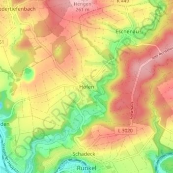
Name: Hofen topographic map, elevation, terrain.
Average elevation: 630 ft
Minimum elevation: 348 ft
Maximum elevation: 860 ft
Make a donation
Gear up for your next adventure:
As an Amazon Associate, this site earns from qualifying purchases at no extra cost to you.