
Make a donation
Gear up for your next adventure:
As an Amazon Associate, this site earns from qualifying purchases at no extra cost to you.
Mellensee topographic map
Click on the map to display elevation.
Make a donation
Gear up for your next adventure:
As an Amazon Associate, this site earns from qualifying purchases at no extra cost to you.
Mellensee
An den Tourismus knüpfte der Ort nach der Wende wieder an. Im Sommer veranstaltet der Ort das Fischerfest mit Musik, Tanz, Geschichte, Angelwettbewerben und anderem mehr. Höhepunkt des Festes ist die Wahl und Krönung der Fischerkönigin. Mellensee besitzt ein Naturstrandbad am Ostufer des Mellensees. Auch Ruderboote können hier ausgeliehen werden.
Make a donation
Gear up for your next adventure:
As an Amazon Associate, this site earns from qualifying purchases at no extra cost to you.
About this map
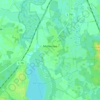
Name: Mellensee topographic map, elevation, terrain.
Average elevation: 128 ft
Minimum elevation: 112 ft
Maximum elevation: 171 ft
Make a donation
Gear up for your next adventure:
As an Amazon Associate, this site earns from qualifying purchases at no extra cost to you.
Other topographic maps
Click on a map to view its topography, its elevation and its terrain.
Mönningfeld
Deutschland > Brandenburg > Teltow-Fläming > Am Mellensee > Fernneuendorf
Average elevation: 161 ft