Marabá topographic map
Click on the map to display elevation.
Marabá
The topography of the municipality of Marabá presents the highest altitudes in the Southeast region of Pará, through the Carajás, Sereno, Buritirama, Paredão, Encontro, Gray and Misteriosa mountains. Of this complex, stands out the Carajás mountain range, like the one of greater size. However, it is in the Serra do Cinzento that the maximum altitude of the municipality of Marabá is found, with 792 meters. The Carajás, Cinzento and Buritirana mountains are located in conservation areas, under federal jurisdiction, called the Tapirapé-Aquiri National Forest ( 196,504 hectares (485,570 acres) sustainable use conservation unit created in 1989.) and the Tapirapé Biological Reserve, where several caves are found. Its forms of relief are encompassed by the morphostructural unit denominated Peripheral Depression of the South of Pará, where they dominate the amazonian plateaus.
About this map
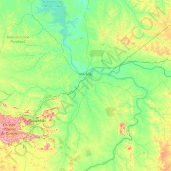
Name: Marabá topographic map, elevation, terrain.
Average elevation: 597 ft
Minimum elevation: 197 ft
Maximum elevation: 2,867 ft
Other topographic maps
Click on a map to view its topography, its elevation and its terrain.
Amazon River
During what many archaeologists called the formative stage, Amazonian societies were deeply involved in the emergence of South America's highland agrarian systems. The trade with Andean civilizations in the terrains of the headwaters in the Andes formed an essential contribution to the social and religious…
Average elevation: 16 ft
Amazon River
During what many archaeologists called the formative stage, Amazonian societies were deeply involved in the emergence of South America's highland agrarian systems. The trade with Andean civilizations in the terrains of the headwaters in the Andes formed an essential contribution to the social and religious…
Average elevation: 62 ft

Amazon River
During what many archaeologists called the formative stage, Amazonian societies were deeply involved in the emergence of South America's highland agrarian systems. The trade with Andean civilizations in the terrains of the headwaters in the Andes formed an essential contribution to the social and religious…
Average elevation: 0 ft


Amazon River
During what many archaeologists called the formative stage, Amazonian societies were deeply involved in the emergence of South America's highland agrarian systems. The trade with Andean civilizations in the terrains of the headwaters in the Andes formed an essential contribution to the social and religious…
Average elevation: 0 ft
Amazon River
During what many archaeologists called the formative stage, Amazonian societies were deeply involved in the emergence of South America's highland agrarian systems. The trade with Andean civilizations in the terrains of the headwaters in the Andes formed an essential contribution to the social and religious…
Average elevation: 16 ft

Amazon River
During what many archaeologists called the formative stage, Amazonian societies were deeply involved in the emergence of South America's highland agrarian systems. The trade with Andean civilizations in the terrains of the headwaters in the Andes formed an essential contribution to the social and religious…
Average elevation: 13 ft
Amazon River
During what many archaeologists called the formative stage, Amazonian societies were deeply involved in the emergence of South America's highland agrarian systems. The trade with Andean civilizations in the terrains of the headwaters in the Andes formed an essential contribution to the social and religious…
Average elevation: 16 ft



Amazon River
During what many archaeologists called the formative stage, Amazonian societies were deeply involved in the emergence of South America's highland agrarian systems. The trade with Andean civilizations in the terrains of the headwaters in the Andes formed an essential contribution to the social and religious…
Average elevation: 30 ft