
Make a donation
Gear up for your next adventure:
As an Amazon Associate, this site earns from qualifying purchases at no extra cost to you.
Tillington topographic map
Click on the map to display elevation.
Make a donation
Gear up for your next adventure:
As an Amazon Associate, this site earns from qualifying purchases at no extra cost to you.
Tillington
A sandstone ridge with an elevation of approximately 170 metres (560 ft) runs east to west across the centre of the parish, from Upperton to River. The north facing scarp slope falls steeply to the low weald where the soils are a mix of Weald Clay with alluvial soils.
Make a donation
Gear up for your next adventure:
As an Amazon Associate, this site earns from qualifying purchases at no extra cost to you.
About this map
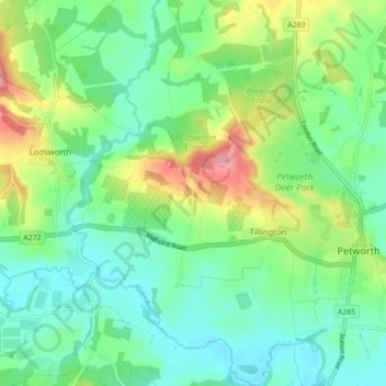
Name: Tillington topographic map, elevation, terrain.
Average elevation: 151 ft
Minimum elevation: 23 ft
Maximum elevation: 446 ft
Make a donation
Gear up for your next adventure:
As an Amazon Associate, this site earns from qualifying purchases at no extra cost to you.
Other topographic maps
Click on a map to view its topography, its elevation and its terrain.