
Make a donation
Gear up for your next adventure:
As an Amazon Associate, this site earns from qualifying purchases at no extra cost to you.
Lesko topographic map
Click on the map to display elevation.
Make a donation
Gear up for your next adventure:
As an Amazon Associate, this site earns from qualifying purchases at no extra cost to you.
Lesko
Lesko [ˈlɛskɔ] (or Lisko until 1926; Ukrainian: Лісько, romanized: Lisko; Latin: Lescow, alias Olesco Lescovium; Yiddish: לינסק, romanized: Linsk) is a town in south-eastern Poland with a population of 5,755 (02.06.2009) situated in the Bieszczady mountains. It is located in the heartland of the Doły (Pits), and its average altitude is 390 metres (1,280 feet) above sea level, although there are some hills located within the confines of the city. Since 2002 it has been the capital of Lesko County.
Make a donation
Gear up for your next adventure:
As an Amazon Associate, this site earns from qualifying purchases at no extra cost to you.
About this map
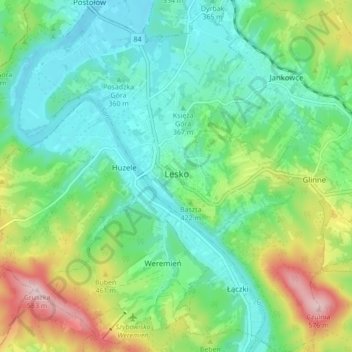
Name: Lesko topographic map, elevation, terrain.
Average elevation: 1,270 ft
Minimum elevation: 1,004 ft
Maximum elevation: 1,900 ft
Make a donation
Gear up for your next adventure:
As an Amazon Associate, this site earns from qualifying purchases at no extra cost to you.
Other topographic maps
Click on a map to view its topography, its elevation and its terrain.