Geolocate

Maslog topographic map

Click on the map to display elevation.

About this map

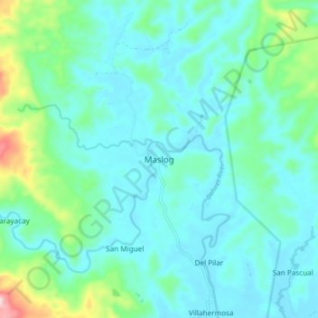
Name: Maslog topographic map, elevation, terrain.

Location: Maslog, Eastern Samar, Eastern Visayas, Philippines (12.11785 125.20717 12.19785 125.28717)

Average elevation: 187 ft

Minimum elevation: 13 ft

Maximum elevation: 991 ft

Other topographic maps

Click on a map to view its topography, its elevation and its terrain.

Borongan City

Philippines > Eastern Samar

Average elevation: 36 ft

Jipapad

Philippines > Eastern Samar

Average elevation: 361 ft

Hilabaan

Philippines > Eastern Samar

Average elevation: 3 ft

Tikling

Philippines > Eastern Samar

Average elevation: 0 ft

Homonhon Island

Philippines > Eastern Samar > Habag

Average elevation: 89 ft

Suluan Island

Philippines > Eastern Samar > Suluan

Average elevation: 39 ft

Manicani Island

Philippines > Eastern Samar > Banaag

Average elevation: 59 ft

Homonhon Island

Philippines > Eastern Samar > Culasi

Average elevation: 89 ft

Leleboon Island

Philippines > Eastern Samar > Sulangan

Average elevation: 13 ft

Oras

Philippines > Eastern Samar > Jipapad

Average elevation: 121 ft

Calicoan Island

Philippines > Eastern Samar > Ngolos

Average elevation: 13 ft

Homonhon Island

Philippines > Eastern Samar > Culasi

Average elevation: 89 ft

Gear up for your next adventure:

🦶Carbon Trekking Poles - Reduce knee impact on steep descents with ultra-light poles
📱Heavy-Duty Phone Cases - Drop-proof and waterproof protection for outdoor navigation
🦟Ultrasonic Repellers - Create a bug-free zone at your camp or rest stop
🗺️NatGeo Topo Maps - High-quality waterproof printed topographic maps of US Parks
Solar GPS Watches - Advanced multisport watches with built-in topographic maps

As an Amazon Associate, this site earns from qualifying purchases at no extra cost to you.