
Thank you for supporting this site ❤️
Make a donation
Make a donation
Gear up for your next adventure:
As an Amazon Associate, this site earns from qualifying purchases at no extra cost to you.
Chontaduro topographic map
Click on the map to display elevation.
Thank you for supporting this site ❤️
Make a donation
Make a donation
Gear up for your next adventure:
As an Amazon Associate, this site earns from qualifying purchases at no extra cost to you.
About this map
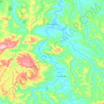
Name: Chontaduro topographic map, elevation, terrain.
Location: Chontaduro, Río Verde, Esmeraldas, Ecuador (0.77835 -79.48349 0.97841 -79.29472)
Average elevation: 551 ft
Minimum elevation: 10 ft
Maximum elevation: 2,021 ft
Thank you for supporting this site ❤️
Make a donation
Make a donation
Gear up for your next adventure:
As an Amazon Associate, this site earns from qualifying purchases at no extra cost to you.