
Make a donation
Gear up for your next adventure:
As an Amazon Associate, this site earns from qualifying purchases at no extra cost to you.
Provincia Tomina topographic map
Click on the map to display elevation.
Make a donation
Gear up for your next adventure:
As an Amazon Associate, this site earns from qualifying purchases at no extra cost to you.
About this map
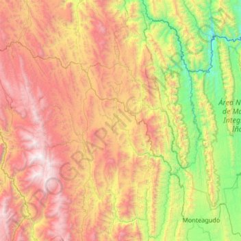
Name: Provincia Tomina topographic map, elevation, terrain.
Location: Provincia Tomina, Chuquisaca, Bolivia (-19.88980 -64.66214 -18.88063 -63.95475)
Average elevation: 6,690 ft
Minimum elevation: 1,939 ft
Maximum elevation: 13,976 ft
Make a donation
Gear up for your next adventure:
As an Amazon Associate, this site earns from qualifying purchases at no extra cost to you.
Other topographic maps
Click on a map to view its topography, its elevation and its terrain.
Machareti
Bolivia > Chuquisaca > Provincia Luis Calvo > Municipio Machareti > Machareti
Average elevation: 2,169 ft
Make a donation
Gear up for your next adventure:
As an Amazon Associate, this site earns from qualifying purchases at no extra cost to you.