Geolocate

Pauriali topographic map

Click on the map to display elevation.

About this map

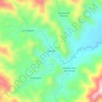
Name: Pauriali topographic map, elevation, terrain.

Location: Pauriali, Mazamari, Satipo, Junín, Perú (-11.35051 -74.60521 -11.31051 -74.56521)

Average elevation: 2,910 ft

Minimum elevation: 2,290 ft

Maximum elevation: 4,137 ft

Other topographic maps

Click on a map to view its topography, its elevation and its terrain.

Provincia de Satipo

Perú > Junín > Mazamari

Average elevation: 1,617 ft

Gear up for your next adventure:

🖼️Topo Map Wall Art - Decorative topographic prints of famous peaks and regions
🧴Hand Sanitizer - Keep hands clean while hiking
🌡️Portable Weather Meter - Track weather conditions on the trail
🔌Solar Panel Charger - Charge gear sustainably outdoors
🥾Women's Hiking Boots - Top-rated trail boots with ankle support and superior grip

As an Amazon Associate, this site earns from qualifying purchases at no extra cost to you.