
Stillwater topographic map
Click on the map to display elevation.
About this map
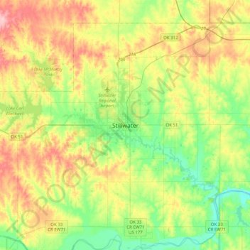
Name: Stillwater topographic map, elevation, terrain.
Location: Stillwater, Payne County, Oklahoma, 74077, United States (35.95563 -97.21857 36.27563 -96.89857)
Average elevation: 968 ft
Minimum elevation: 794 ft
Maximum elevation: 1,234 ft
Payne County trails, hiking, mountain biking, running and outdoor activities
Other topographic maps
Click on a map to view its topography, its elevation and its terrain.
Oklahoma State University
United States > Oklahoma > Payne County > Stillwater
Average elevation: 919 ft
The Botanic Garden at Oklahoma State University
United States > Oklahoma > Payne County > Stillwater
Average elevation: 902 ft