Geolocate

Passadumkeag topographic map

Click on the map to display elevation.

About this map

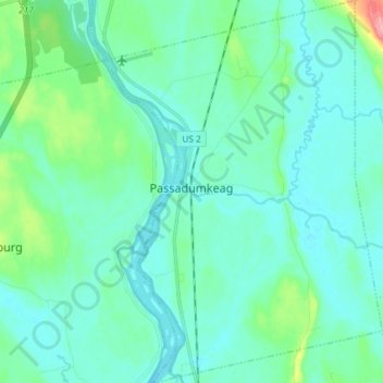
Name: Passadumkeag topographic map, elevation, terrain.

Location: Passadumkeag, Penobscot County, Maine, 04475, United States (45.13264 -68.64533 45.23536 -68.54055)

Average elevation: 167 ft

Minimum elevation: 115 ft

Maximum elevation: 440 ft

Penobscot County trails, hiking, mountain biking, running and outdoor activities

Other topographic maps

Click on a map to view its topography, its elevation and its terrain.

Bangor Hill

United States > Maine > Penobscot County > Orono

Average elevation: 203 ft

Hudson Hill

United States > Maine > Penobscot County > Hudson

Average elevation: 253 ft

Blackcap

United States > Maine > Penobscot County > Eddington

Average elevation: 571 ft

Sugar Island

United States > Maine > Penobscot County > Greenbush

Average elevation: 135 ft

Tiger Rips

United States > Maine > Penobscot County

Average elevation: 741 ft

State Island

United States > Maine > Penobscot County

Average elevation: 482 ft

Lincoln

United States > Maine > Penobscot County > Lincoln

Average elevation: 272 ft

Gear up for your next adventure:

🚁Photography Drones - Capture stunning aerial views of landforms and topography
🌡️Handheld Weather Meters - Measure wind, temp, and pressure for safe mountain travel
🌲Outdoor Survival Books - Best books on survival skills
🕶️Glacier Sunglasses - Side shields to protect eyes from high-altitude snow glare
🥤Water Filter Bottle - All‑in‑one filter bottle for safe hydration

As an Amazon Associate, this site earns from qualifying purchases at no extra cost to you.