Geolocate

Borongan topographic map

Click on the map to display elevation.

About this map

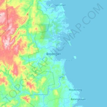
Name: Borongan topographic map, elevation, terrain.

Location: Borongan, Eastern Samar, Eastern Visayas, 6800, Philippines (11.44799 125.27224 11.76799 125.59224)

Average elevation: 371 ft

Minimum elevation: -3 ft

Maximum elevation: 2,162 ft

Other topographic maps

Click on a map to view its topography, its elevation and its terrain.

Borongan City

Philippines > Eastern Samar

Average elevation: 36 ft

Jipapad

Philippines > Eastern Samar

Average elevation: 361 ft

Hilabaan

Philippines > Eastern Samar

Average elevation: 3 ft

Tikling

Philippines > Eastern Samar

Average elevation: 0 ft

Homonhon Island

Philippines > Eastern Samar > Habag

Average elevation: 89 ft

Suluan Island

Philippines > Eastern Samar > Suluan

Average elevation: 39 ft

Manicani Island

Philippines > Eastern Samar > Banaag

Average elevation: 59 ft

Homonhon Island

Philippines > Eastern Samar > Culasi

Average elevation: 89 ft

Leleboon Island

Philippines > Eastern Samar > Sulangan

Average elevation: 13 ft

Oras

Philippines > Eastern Samar > Jipapad

Average elevation: 121 ft

Calicoan Island

Philippines > Eastern Samar > Ngolos

Average elevation: 13 ft

Homonhon Island

Philippines > Eastern Samar > Culasi

Average elevation: 89 ft

Gear up for your next adventure:

🛏️Cold Weather Sleeping Bag - Warm sleeping bag for cold conditions
🩹Survival Bandages - High‑quality bandages for emergencies
🔭Compact Binoculars - HD vision for scouting terrain and identifying distant landmarks
🦺Reflective Outdoor Gear - Safety gear for low‑light conditions
🔥Plasma Lighters - Windproof lighters that work in any weather condition

As an Amazon Associate, this site earns from qualifying purchases at no extra cost to you.