Geolocate

Boot topographic map

Click on the map to display elevation.

About this map

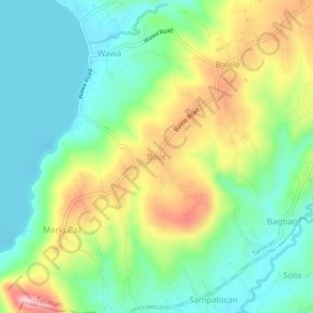
Name: Boot topographic map, elevation, terrain.

Location: Boot, Tanauan, Batangas, Calabarzon, 4232, Philippines (14.03083 121.06249 14.07083 121.10249)

Average elevation: 233 ft

Minimum elevation: 0 ft

Maximum elevation: 656 ft

Other topographic maps

Click on a map to view its topography, its elevation and its terrain.

Maria Paz

Philippines > Batangas > Tanauan

Average elevation: 210 ft

Barangay 3

Philippines > Batangas > Tanauan > Hidalgo

Average elevation: 518 ft

Barangay 5

Philippines > Batangas > Tanauan > Hidalgo

Average elevation: 505 ft

Suplang

Philippines > Batangas > Tanauan

Average elevation: 810 ft

Barangay 5

Philippines > Batangas > Tanauan > Hidalgo

Average elevation: 505 ft

Gear up for your next adventure:

🌲Outdoor Survival Books - Best books on survival skills
🛌Ultralight Sleeping Bags - Compact down bags for cold nights in the wilderness
🧦Hiking Socks - Comfortable socks to prevent blisters on long hikes
🔥Fast-Boil Camping Stoves - Efficient cooking systems for quick trail meals
🗃️Trail First Aid Kit - Essential kit for outdoor injuries and emergencies

As an Amazon Associate, this site earns from qualifying purchases at no extra cost to you.