
Make a donation
Gear up for your next adventure:
As an Amazon Associate, this site earns from qualifying purchases at no extra cost to you.
Markegem topographic map
Click on the map to display elevation.
Make a donation
Gear up for your next adventure:
As an Amazon Associate, this site earns from qualifying purchases at no extra cost to you.
Markegem
Markegem ligt in Zandlemig Vlaanderen op een hoogte van 12-18 meter. In het noordwesten loopt de Oude Mandelbeek, een vroegere arm van de Leie. Deze komt ten westen van de dorpskom uit in de Mandel, welke naar de Leie stroomt. Ten oosten van de dorpskom ligt een stelsel van kleine beken dat naar het noordoosten afvloeit in de Leie.
Make a donation
Gear up for your next adventure:
As an Amazon Associate, this site earns from qualifying purchases at no extra cost to you.
About this map
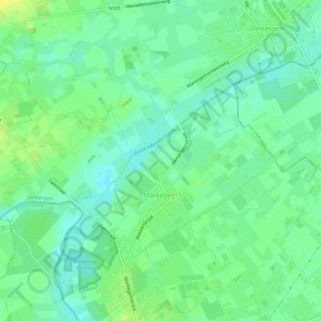
Name: Markegem topographic map, elevation, terrain.
Average elevation: 39 ft
Minimum elevation: 10 ft
Maximum elevation: 79 ft
Make a donation
Gear up for your next adventure:
As an Amazon Associate, this site earns from qualifying purchases at no extra cost to you.
Other topographic maps
Click on a map to view its topography, its elevation and its terrain.
Make a donation
Gear up for your next adventure:
As an Amazon Associate, this site earns from qualifying purchases at no extra cost to you.