
Make a donation
Gear up for your next adventure:
As an Amazon Associate, this site earns from qualifying purchases at no extra cost to you.
Mechernich topographic map
Click on the map to display elevation.
Make a donation
Gear up for your next adventure:
As an Amazon Associate, this site earns from qualifying purchases at no extra cost to you.
About this map
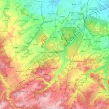
Name: Mechernich topographic map, elevation, terrain.
Average elevation: 1,093 ft
Minimum elevation: 561 ft
Maximum elevation: 1,768 ft
Make a donation
Gear up for your next adventure:
As an Amazon Associate, this site earns from qualifying purchases at no extra cost to you.
Other topographic maps
Click on a map to view its topography, its elevation and its terrain.
Wachendorf
Alemanha > Renânia do Norte-Vestfália > Kreis Euskirchen > Mechernich
Average elevation: 922 ft
Rißdorf
Alemanha > Renânia do Norte-Vestfália > Kreis Euskirchen > Mechernich
Average elevation: 1,024 ft
Wachendorf
Alemanha > Renânia do Norte-Vestfália > Kreis Euskirchen > Mechernich
Average elevation: 922 ft