
Make a donation
Gear up for your next adventure:
As an Amazon Associate, this site earns from qualifying purchases at no extra cost to you.
Tacaná topographic map
Click on the map to display elevation.
Make a donation
Gear up for your next adventure:
As an Amazon Associate, this site earns from qualifying purchases at no extra cost to you.
Tacaná
En 1905, durante el gobierno del licenciado Manuel Estrada Cabrera y a solicitud de este, el teniente coronel e ingeniero Francisco Vela construyó en el Hipódromo del Norte de la Ciudad de Guatemala el Mapa en Relieve del país; en el mapa, el volcán Tacaná está mostrado con líneas de nivel que muestran su considerable elevación.
Make a donation
Gear up for your next adventure:
As an Amazon Associate, this site earns from qualifying purchases at no extra cost to you.
About this map
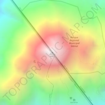
Name: Tacaná topographic map, elevation, terrain.
Location: Tacaná, Sibinal, San Marcos, Guatemala (15.13243 -92.10847 15.13253 -92.10837)
Average elevation: 11,417 ft
Minimum elevation: 9,459 ft
Maximum elevation: 13,366 ft
Make a donation
Gear up for your next adventure:
As an Amazon Associate, this site earns from qualifying purchases at no extra cost to you.