
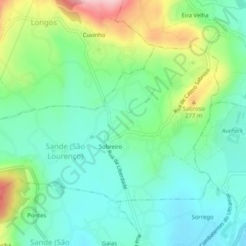
Sande (São Lourenço) topographic map
Interactive map
Click on the map to display elevation.
About this map
Name: Sande (São Lourenço) topographic map, elevation, terrain.
Average elevation: 597 ft
Minimum elevation: 394 ft
Maximum elevation: 1,073 ft
Other topographic maps
Click on a map to view its topography, its elevation and its terrain.
Caldas das Taipas
Portugal > Braga > Guimarães > Caldas das Taipas
Caldas das Taipas, Guimarães, Braga, 4805-133, Portugal
Average elevation: 663 ft