Geolocate

Terre Haute topographic map

Click on the map to display elevation.

About this map

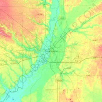
Name: Terre Haute topographic map, elevation, terrain.

Location: Terre Haute, Vigo County, Indiana, 47809, United States (39.30670 -87.57391 39.62670 -87.25391)

Average elevation: 554 ft

Minimum elevation: 433 ft

Maximum elevation: 745 ft

Vigo County trails, hiking, mountain biking, running and outdoor activities

Gear up for your next adventure:

🚗GPS Dash Cams - Record your scenic drives through mountain passes and canyons
🪑Portable Camp Table - Compact table for campsite meals
📷Action Camera - Capture your outdoor adventures in HD
🪶LED Camping Lantern - Bright lantern for camp lighting
🔦LED Headlamp - Bright and durable LED headlamp for night navigation

As an Amazon Associate, this site earns from qualifying purchases at no extra cost to you.