Geolocate

Dansa topographic map

Click on the map to display elevation.

About this map

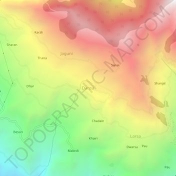
Name: Dansa topographic map, elevation, terrain.

Location: Dansa, Rampur, Shimla, Himachal Pradesh, 172022, India (31.39883 77.64934 31.43883 77.68934)

Average elevation: 6,565 ft

Minimum elevation: 3,419 ft

Maximum elevation: 9,564 ft

Other topographic maps

Click on a map to view its topography, its elevation and its terrain.

Daranghati WLS

India > Himachal Pradesh > Rampur > Kasha

Average elevation: 11,696 ft

Gear up for your next adventure:

🧭Orienteering Set - Complete compass and map reading kit
Camping Coffee Makers - Enjoy premium coffee at the summit or campsite
🪶Trail Camera - Capture wildlife on your hikes
🩹Survival Bandages - High‑quality bandages for emergencies
🛌Ultralight Sleeping Bags - Compact down bags for cold nights in the wilderness

As an Amazon Associate, this site earns from qualifying purchases at no extra cost to you.