Geolocate

Kaiping topographic map

Click on the map to display elevation.

About this map

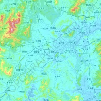
Name: Kaiping topographic map, elevation, terrain.

Location: Kaiping, Jiangmen, Guangdong Province, 529300, China (21.97319 112.23036 22.66875 112.81145)

Average elevation: 266 ft

Minimum elevation: -16 ft

Maximum elevation: 4,019 ft

Other topographic maps

Click on a map to view its topography, its elevation and its terrain.

Taicheng

China > Guangdong Province > Jiangmen

Average elevation: 59 ft

Gear up for your next adventure:

GPS Sports Watch - GPS watch for running, hiking and training
Backpacking Tent - Lightweight and durable tent for multi‑day hikes
👖Convertible Hiking Pants - Versatile zip-off pants for changing altitudes and temperatures
🧭GPS Watch Accessories - Bands and chargers for GPS watches
🪶Wildlife Field Guides - Learn animal tracking and species ID

As an Amazon Associate, this site earns from qualifying purchases at no extra cost to you.