Geolocate

Frostburg topographic map

Interactive map

Click on the map to display elevation.

Frostburg

Due to its average elevation of 2,000 feet (610 m) above sea level and location near the Allegheny Front, Frostburg has a colder, wetter climate than much of the rest of the state, and falls in USDA hardiness zone 6b. Under the Köppen climate classification, it has a humid continental climate (Dfb), with cold, snowy winters, and warm, humid summers. The daily mean temperature ranges from 26.0 °F (−3.3 °C) in January to 69.0 °F (20.6 °C) in July. Sub-0 °F (−18 °C) occur on 3.8 nights per year, while, on average, there are 1.4 days with 90 °F (32 °C)+ highs, though these are not recorded every year. Due to orographic lift, driving conditions on I-68 and US 40 can be very hazardous despite timely state and local road maintenance services, and the town averages just over 80 inches (200 cm) of snowfall a season; significant falls can occur as early as October and as late as May. Frostburg's greatest one-month snowfall was 67 inches (170 cm) in January 1978, and Frostburg is second in Maryland for the greatest single-season snowfall with a total of 180 inches (460 cm) in the winter of 1995−96.

Wikipedia (CC-BY-SA 3.0)

About this map

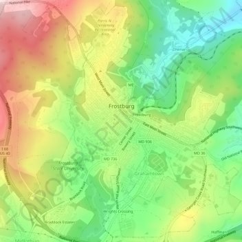
Name: Frostburg topographic map, elevation, terrain.

Location: Frostburg, Allegany County, Maryland, 21532, United States (39.63471 -78.95116 39.67617 -78.90082)

Average elevation: 2,034 ft

Minimum elevation: 1,496 ft

Maximum elevation: 2,697 ft

Allegany County trails, hiking, mountain biking, running and outdoor activities

Other topographic maps

Click on a map to view its topography, its elevation and its terrain.

La Vale

United States > Maryland > Allegany County

Average elevation: 1,030 ft

Bel Air

United States > Maryland > Allegany County

Average elevation: 863 ft

Cresaptown

United States > Maryland > Allegany County

Average elevation: 846 ft

Little Orleans

United States > Maryland > Allegany County

Average elevation: 633 ft

Oldtown

United States > Maryland > Allegany County

Average elevation: 636 ft

Bowmans Addition

United States > Maryland > Allegany County

Average elevation: 1,132 ft

Corriganville

United States > Maryland > Allegany County

Average elevation: 1,073 ft

Moscow

United States > Maryland > Allegany County

Average elevation: 1,785 ft

Ellerslie

United States > Maryland > Allegany County

Average elevation: 1,079 ft

Zihlman

United States > Maryland > Allegany County

Zihlman is located along Maryland Route 36, 1.5 miles (2.4 km) northeast of and 500 feet (150 m) lower in elevation than Frostburg. Mount Savage is 3 miles (5 km) further northeast along MD 36.

Average elevation: 1,936 ft

Midlothian

United States > Maryland > Allegany County

Average elevation: 2,093 ft

Franklin

United States > Maryland > Allegany County

Average elevation: 1,486 ft

Pinto

United States > Maryland > Allegany County > Bel Air

Average elevation: 810 ft

McCoole

United States > Maryland > Allegany County

Average elevation: 945 ft

Eckhart Mines

United States > Maryland > Allegany County

Average elevation: 1,880 ft

Pleasant Grove

United States > Maryland > Allegany County

Average elevation: 1,047 ft

Dawson

United States > Maryland > Allegany County

Average elevation: 1,063 ft

McKenzie

United States > Maryland > Allegany County

Average elevation: 915 ft

Spring Gap

United States > Maryland > Allegany County

Average elevation: 715 ft

Nikep

United States > Maryland > Allegany County

Average elevation: 1,841 ft

Klondike

United States > Maryland > Allegany County

Average elevation: 2,060 ft

Bowling Green

United States > Maryland > Allegany County

Average elevation: 984 ft

Bier

United States > Maryland > Allegany County

Average elevation: 938 ft

Amcelle

United States > Maryland > Allegany County > Potomac Park

Average elevation: 955 ft

Carlos

United States > Maryland > Allegany County

Average elevation: 2,083 ft

North Branch

United States > Maryland > Allegany County

Average elevation: 791 ft

Vale Summit

United States > Maryland > Allegany County

Average elevation: 2,149 ft

Potomac Park

United States > Maryland > Allegany County

Average elevation: 948 ft

Ocean

United States > Maryland > Allegany County

Average elevation: 1,946 ft

Detmold

United States > Maryland > Allegany County

Average elevation: 1,893 ft

Danville

United States > Maryland > Allegany County

Average elevation: 1,168 ft

Woodland

United States > Maryland > Allegany County

Average elevation: 1,962 ft

National

United States > Maryland > Allegany County

Average elevation: 1,949 ft

Grahamtown

United States > Maryland > Allegany County

Average elevation: 1,972 ft

Gilmore

United States > Maryland > Allegany County

Average elevation: 1,972 ft

Clarysville

United States > Maryland > Allegany County

Average elevation: 1,946 ft

Barrelville

United States > Maryland > Allegany County

Average elevation: 1,437 ft

Mexico

United States > Maryland > Allegany County

Average elevation: 735 ft

Flintstone

United States > Maryland > Allegany County

Average elevation: 965 ft

Mount Savage

United States > Maryland > Allegany County

A small blue-collar community, Mount Savage lies at the base of Big Savage Mountain in the Allegheny Mountains, between the cities of Frostburg and Cumberland. It began as a small farming settlement in the mid-19th century, but it was not until 1844 that the region was put on the nation's map with the pressing…

Average elevation: 1,562 ft

Rawlings

United States > Maryland > Allegany County

Average elevation: 965 ft

Jackson Mountain

United States > Maryland > Allegany County

Average elevation: 1,886 ft