
Turmi topographic map
Click on the map to display elevation.
Turmi
Turmi is a market town in south-western Ethiopia. Located in the Debub Omo Zone of the South Ethiopia Regional State, the town has a latitude and longitude of 4°58′N 36°29′E / 4.967°N 36.483°E / 4.967; 36.483 with an elevation of 925 metres above sea level.
About this map
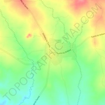
Name: Turmi topographic map, elevation, terrain.
Location: Turmi, South Omo, South Ethiopia Regional State, Ethiopia (4.94835 36.46779 4.98835 36.50779)
Average elevation: 3,022 ft
Minimum elevation: 2,897 ft
Maximum elevation: 3,159 ft
Other topographic maps
Click on a map to view its topography, its elevation and its terrain.
Bombe
Ethiopia > South Ethiopia Regional State
Bombe (Geʽez: ቦምቤ) is a town and separate district in Wolayita Zone of the South Ethiopia Regional State, Ethiopia. Bombe town is located 325 km (202 mi) and 55 km (34 mi) away from Addis Ababa and Wolaita Sodo town through Hossana exit, respectively. Bombe town is used as an administrative capital of…
Average elevation: 4,977 ft
Boditi
Ethiopia > South Ethiopia Regional State
Boditi, (Amharic: ቦዲቲ) or (Wolayttattuwa: Bodditte) is a city and separate district in south central Ethiopia. The city is located in the Wolaita Zone of the South Ethiopia Regional State. This city has a latitude and longitude of 6°58′N 37°52′E / 6.967°N 37.867°E / 6.967; 37.867 with an…
Average elevation: 6,503 ft
Nech Sar National Park
Ethiopia > South Ethiopia Regional State > Arba Minch
Average elevation: 3,986 ft