Geolocate

Chyhyryn topographic map

Click on the map to display elevation.

Chyhyryn

The city is on the banks of Tiasmyn River and lies at an altitude of 124 metres above mean sea level. Minor industries, such as food and furniture factories, are the basis of the town economy in the 21st century.

Wikipedia (CC-BY-SA 3.0)

About this map

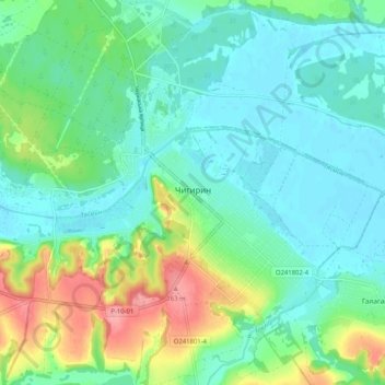
Name: Chyhyryn topographic map, elevation, terrain.

Location: Chyhyryn, Чигиринська міська громада, Cherkasy Raion, Cherkasy Oblast, 20901, Ukraine (49.05471 32.59939 49.09908 32.70160)

Average elevation: 315 ft

Minimum elevation: 233 ft

Maximum elevation: 528 ft

Other topographic maps

Click on a map to view its topography, its elevation and its terrain.

Ratseve

Ukraine > Cherkasy Oblast

Average elevation: 312 ft

Dnieper River

Ukraine > Cherkasy Oblast

The source of the Dnieper is the sedge bogs (Akseninsky Mokh) of the Valdai Hills in central Russia, at an elevation of 220 m (720 ft). For 115 km (71 mi) of its length, it serves as the border between Belarus and Ukraine. Its estuary, or liman, used to be defended by the strong fortress of Ochakiv.

Average elevation: 272 ft

Kheilove

Ukraine > Cherkasy Oblast

Average elevation: 761 ft

Vodianyky

Ukraine > Cherkasy Oblast

Average elevation: 689 ft

Talne

Ukraine > Cherkasy Oblast

Average elevation: 564 ft

Zhashkiv

Ukraine > Cherkasy Oblast

Average elevation: 755 ft

Kostiantynivka

Ukraine > Cherkasy Oblast

Average elevation: 404 ft

П’ятихатки

Ukraine > Cherkasy Oblast > Cherkasy

Average elevation: 315 ft

Zabiliany

Ukraine > Cherkasy Oblast

Average elevation: 850 ft

Impact crater

Ukraine > Cherkasy Oblast

Average elevation: 807 ft

Zhurzhyntsi

Ukraine > Cherkasy Oblast

Average elevation: 719 ft

Bilashky

Ukraine > Cherkasy Oblast

Average elevation: 623 ft

Hryhorivka

Ukraine > Cherkasy Oblast > Hryhorivka

Average elevation: 420 ft

Katerynopil

Ukraine > Cherkasy Oblast > Katerynopil

Average elevation: 512 ft

Zavadivka

Ukraine > Cherkasy Oblast > Zavadivka

Average elevation: 541 ft

Rozsokhuvatka

Ukraine > Cherkasy Oblast > Rozsokhuvatka

Average elevation: 630 ft

Mykhailivka

Ukraine > Cherkasy Oblast > Mykhailivka

Average elevation: 610 ft

Chaplynka

Ukraine > Cherkasy Oblast > Chaplynka

Average elevation: 643 ft

Antonivka

Ukraine > Cherkasy Oblast > Antonivka

Average elevation: 574 ft

Gear up for your next adventure:

🚪Portable Camp Chair - Foldable chair for comfort at camp
🛠️Backpacking Tool Kit - Essential toolkit for outdoor repairs
🔋Rechargeable Batteries - Power up your outdoor devices
Backpacking Tents - Weight-optimized shelters for multi-day topographic surveys
☀️Outdoor Sunscreen - High protection sunscreen for outdoor activities

As an Amazon Associate, this site earns from qualifying purchases at no extra cost to you.