
Sint-Joris topographic map
Click on the map to display elevation.
About this map
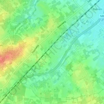
Name: Sint-Joris topographic map, elevation, terrain.
Location: Sint-Joris, Alken, Tongeren, Limburg, 3570, België (50.85168 5.25140 50.89168 5.29140)
Average elevation: 164 ft
Minimum elevation: 112 ft
Maximum elevation: 259 ft
Other topographic maps
Click on a map to view its topography, its elevation and its terrain.
Alken
België > Limburg > Tongeren > Alken
Alken is gelegen in Vochtig-Haspengouw. Het dorp heeft zich ontwikkeld in de vallei van de Herk, die in noordwaartse richting stroomt en de Mombeek in zich opneemt. Hier bevindt zich het natuurreservaat Mombeekvallei waar ook gemarkeerde wandelingen zijn uitgezet. Andere beken in Alken zijn de Simsebeek en de…
Average elevation: 148 ft