
Make a donation
Gear up for your next adventure:
As an Amazon Associate, this site earns from qualifying purchases at no extra cost to you.
Schüpbach topographic map
Click on the map to display elevation.
Make a donation
Gear up for your next adventure:
As an Amazon Associate, this site earns from qualifying purchases at no extra cost to you.
About this map
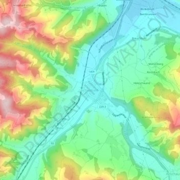
Name: Schüpbach topographic map, elevation, terrain.
Average elevation: 2,490 ft
Minimum elevation: 2,116 ft
Maximum elevation: 3,186 ft
Make a donation
Gear up for your next adventure:
As an Amazon Associate, this site earns from qualifying purchases at no extra cost to you.
Other topographic maps
Click on a map to view its topography, its elevation and its terrain.
Lauperswil
Schweiz > Bern > Verwaltungskreis Emmental
Auf dem Gebiet der Gemeinde liegt die Ruine der Höhenburg Wartenstein. Der Zeitpunkt der Erbauung ist nicht genau bekannt. Als erste Besitzer werden ab 1228 die Ritter Swaro von Wartenstein genannt.
Average elevation: 2,507 ft