Geolocate

Inver topographic map

Click on the map to display elevation.

About this map

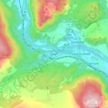
Name: Inver topographic map, elevation, terrain.

Location: Inver, Perth and Kinross, Scotland, PH8 0JR, United Kingdom (56.54107 -3.62193 56.58107 -3.58193)

Average elevation: 528 ft

Minimum elevation: 131 ft

Maximum elevation: 1,280 ft

Gear up for your next adventure:

🔥Plasma Lighters - Windproof lighters that work in any weather condition
🪶Trail Camera - Capture wildlife on your hikes
🦺Reflective Outdoor Gear - Safety gear for low‑light conditions
🚗GPS Dash Cams - Record your scenic drives through mountain passes and canyons
🪶Multi‑Purpose Knife - Useful blade for camp and trail

As an Amazon Associate, this site earns from qualifying purchases at no extra cost to you.