
Make a donation
Gear up for your next adventure:
As an Amazon Associate, this site earns from qualifying purchases at no extra cost to you.
Westmoreland topographic map
Click on the map to display elevation.
Make a donation
Gear up for your next adventure:
As an Amazon Associate, this site earns from qualifying purchases at no extra cost to you.
About this map
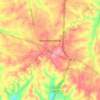
Name: Westmoreland topographic map, elevation, terrain.
Average elevation: 889 ft
Minimum elevation: 656 ft
Maximum elevation: 1,017 ft
Sumner County trails, hiking, mountain biking, running and outdoor activities
Make a donation
Gear up for your next adventure:
As an Amazon Associate, this site earns from qualifying purchases at no extra cost to you.
Other topographic maps
Click on a map to view its topography, its elevation and its terrain.
Bluegrass Meadows
United States > Tennessee > Sumner County > Hendersonville
Average elevation: 512 ft
Lake Club Estates
United States > Tennessee > Sumner County > Hendersonville
Average elevation: 509 ft
Make a donation
Gear up for your next adventure:
As an Amazon Associate, this site earns from qualifying purchases at no extra cost to you.
Scottish Highlands
United States > Tennessee > Sumner County > Hendersonville
Average elevation: 515 ft
Curtiswood
United States > Tennessee > Sumner County > Hendersonville > Curtiswood
Average elevation: 472 ft