
Colleyville topographic map
Click on the map to display elevation.
About this map
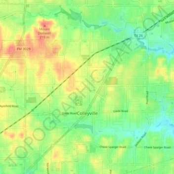
Name: Colleyville topographic map, elevation, terrain.
Location: Colleyville, Tarrant County, Texas, 76034, United States (32.86012 -97.18679 32.92374 -97.09982)
Average elevation: 627 ft
Minimum elevation: 545 ft
Maximum elevation: 725 ft
Tarrant County trails, hiking, mountain biking, running and outdoor activities
Other topographic maps
Click on a map to view its topography, its elevation and its terrain.
Will Rogers Memorial Center
United States > Texas > Tarrant County > Fort Worth
Average elevation: 594 ft