Geolocate

Oss topographic map

Click on the map to display elevation.

Oss

Dutch Topographic map of Oss (municipality), June 2015

Wikipedia (CC-BY-SA 3.0)

About this map

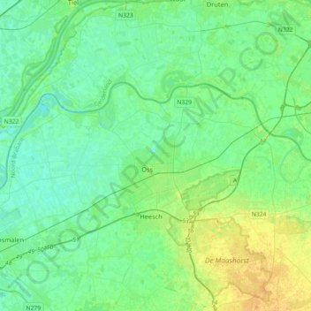
Name: Oss topographic map, elevation, terrain.

Location: Oss, North Brabant, Netherlands (51.72587 5.35351 51.83075 5.71123)

Average elevation: 26 ft

Minimum elevation: -3 ft

Maximum elevation: 95 ft

Other topographic maps

Click on a map to view its topography, its elevation and its terrain.

Berkhoek

Netherlands > North Brabant > Udenhout

Average elevation: 36 ft

Gear up for your next adventure:

💧Water Purification System - Clean water on the trail with reliable purifiers
🍳Camping Cook Set - Complete cookware for outdoor meals
🧢Sun Protection Hats - Wide-brimmed and UPF-rated hats for high-altitude sun safety
🚪Portable Camp Chair - Foldable chair for comfort at camp
🧣Hiking Neck Gaiter - Multi‑use neck protection for outdoor weather

As an Amazon Associate, this site earns from qualifying purchases at no extra cost to you.