
Make a donation
Gear up for your next adventure:
As an Amazon Associate, this site earns from qualifying purchases at no extra cost to you.
Berga topographic map
Click on the map to display elevation.
Make a donation
Gear up for your next adventure:
As an Amazon Associate, this site earns from qualifying purchases at no extra cost to you.
About this map
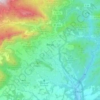
Name: Berga topographic map, elevation, terrain.
Location: Berga, Berguéda, Barcelone, Catalogne, 08600, Espagne (42.07109 1.79901 42.12394 1.88774)
Average elevation: 2,569 ft
Minimum elevation: 1,562 ft
Maximum elevation: 5,597 ft
Make a donation
Gear up for your next adventure:
As an Amazon Associate, this site earns from qualifying purchases at no extra cost to you.
Other topographic maps
Click on a map to view its topography, its elevation and its terrain.
Castellar de n'Hug
Espagne > Catalogne > Berguéda > Castellar de n'Hug > Castellar de n'Hug
Average elevation: 4,925 ft
Sant Jaume de Frontanyà
Espagne > Catalogne > Berguéda > Sant Jaume de Frontanyà > Sant Jaume de Frontanyà
Average elevation: 3,714 ft
la Pobla de Lillet
Espagne > Catalogne > Berguéda > la Pobla de Lillet > la Pobla de Lillet
Le village est situé dans la Vallée de Lillet, sur le versant nord, à 10 km des fontaines du Llobregat. Son altitude est de 843m. Le village est séparé de Castellar de n'Hug par le pic de Saint Eloi et la chaîne des Comes. Plus loin, se trouvent les montagnes du Cadí et du Moixeró. À l'ouest le…
Average elevation: 3,448 ft
Make a donation
Gear up for your next adventure:
As an Amazon Associate, this site earns from qualifying purchases at no extra cost to you.