
Hartsop topographic map
Click on the map to display elevation.
About this map
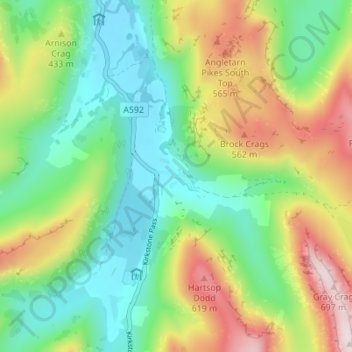
Name: Hartsop topographic map, elevation, terrain.
Average elevation: 1,148 ft
Minimum elevation: 492 ft
Maximum elevation: 2,320 ft
Other topographic maps
Click on a map to view its topography, its elevation and its terrain.
Brown Cove Tarn
United Kingdom > England > Westmorland and Furness > Patterdale
Average elevation: 2,293 ft
Brothers Water
United Kingdom > England > Westmorland and Furness > Patterdale > Hartsop
Average elevation: 978 ft
Norfolk Isle
United Kingdom > England > Westmorland and Furness > Patterdale
Average elevation: 853 ft