Geolocate

Alexisbad topographic map

Click on the map to display elevation.

About this map

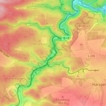
Name: Alexisbad topographic map, elevation, terrain.

Location: Alexisbad, Harzgerode, Landkreis Harz, Saxony-Anhalt, Germany (51.62994 11.09653 51.66994 11.13653)

Average elevation: 1,257 ft

Minimum elevation: 886 ft

Maximum elevation: 1,503 ft

Gear up for your next adventure:

🧯Emergency Survival Kit - All‑in‑one survival essentials for the backcountry
🗻Climbing Gear Basics - Essential gear for beginner climbers
👖Convertible Hiking Pants - Versatile zip-off pants for changing altitudes and temperatures
📡GPS Antenna Upgrade - Enhance GPS reception in remote terrain
🎁Geography Themed Gifts - Unique gift ideas for map lovers and geography enthusiasts

As an Amazon Associate, this site earns from qualifying purchases at no extra cost to you.