Geolocate

Cannobio topographic map

Click on the map to display elevation.

About this map

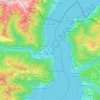
Name: Cannobio topographic map, elevation, terrain.

Location: Cannobio, Verbano-Cusio-Ossola, Piedmont, 28822, Italy (46.00821 8.59328 46.12342 8.72897)

Average elevation: 2,133 ft

Minimum elevation: 600 ft

Maximum elevation: 7,083 ft

Gear up for your next adventure:

🌧️Backpack Rain Cover - Keep gear dry in wet weather
🧯Emergency Survival Kit - All‑in‑one survival essentials for the backcountry
🥾Women's Hiking Boots - Top-rated trail boots with ankle support and superior grip
🖼️Topo Map Wall Art - Decorative topographic prints of famous peaks and regions
🛶Inflatable Kayak - Portable kayak for rivers, lakes, and expeditions

As an Amazon Associate, this site earns from qualifying purchases at no extra cost to you.