
Thank you for supporting this site ❤️
Make a donation
Make a donation
Gear up for your next adventure:
As an Amazon Associate, this site earns from qualifying purchases at no extra cost to you.
Rekong Peo topographic map
Click on the map to display elevation.
Thank you for supporting this site ❤️
Make a donation
Make a donation
Gear up for your next adventure:
As an Amazon Associate, this site earns from qualifying purchases at no extra cost to you.
About this map
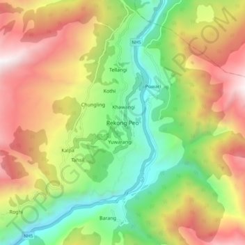
Name: Rekong Peo topographic map, elevation, terrain.
Location: Rekong Peo, Kalpa, Kinnaur, Himachal Pradesh, 172107, India (31.50214 78.23082 31.58214 78.31082)
Average elevation: 9,350 ft
Minimum elevation: 6,017 ft
Maximum elevation: 13,593 ft
Thank you for supporting this site ❤️
Make a donation
Make a donation
Gear up for your next adventure:
As an Amazon Associate, this site earns from qualifying purchases at no extra cost to you.