
Thank you for supporting this site ❤️
Make a donation
Make a donation
Gear up for your next adventure:
As an Amazon Associate, this site earns from qualifying purchases at no extra cost to you.
Jasenice topographic map
Click on the map to display elevation.
Thank you for supporting this site ❤️
Make a donation
Make a donation
Gear up for your next adventure:
As an Amazon Associate, this site earns from qualifying purchases at no extra cost to you.
About this map
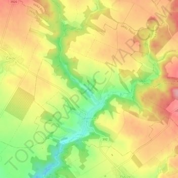
Name: Jasenice topographic map, elevation, terrain.
Location: Jasenice, okres Třebíč, Vysočina Region, Czechia (49.25090 16.14763 49.27621 16.19920)
Average elevation: 1,535 ft
Minimum elevation: 1,299 ft
Maximum elevation: 1,719 ft
Thank you for supporting this site ❤️
Make a donation
Make a donation
Gear up for your next adventure:
As an Amazon Associate, this site earns from qualifying purchases at no extra cost to you.