
Make a donation
Gear up for your next adventure:
As an Amazon Associate, this site earns from qualifying purchases at no extra cost to you.
Rehlingen-Siersburg topographic map
Click on the map to display elevation.
Make a donation
Gear up for your next adventure:
As an Amazon Associate, this site earns from qualifying purchases at no extra cost to you.
About this map
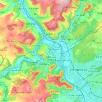
Name: Rehlingen-Siersburg topographic map, elevation, terrain.
Average elevation: 820 ft
Minimum elevation: 545 ft
Maximum elevation: 1,332 ft
Make a donation
Gear up for your next adventure:
As an Amazon Associate, this site earns from qualifying purchases at no extra cost to you.
Other topographic maps
Click on a map to view its topography, its elevation and its terrain.
Litermont
Deutschland > Saarland > Landkreis Saarlouis > Nalbach
Der im Saarland gelegene Litermont ist ein Höhenzug von bis zu 414,2 m ü. NHN und erstreckt sich größtenteils in das Nalbacher Tal, mit kleineren Ausläufern bis nach Düppenweiler.
Average elevation: 1,004 ft
Make a donation
Gear up for your next adventure:
As an Amazon Associate, this site earns from qualifying purchases at no extra cost to you.