
Make a donation
Gear up for your next adventure:
As an Amazon Associate, this site earns from qualifying purchases at no extra cost to you.
Sandridge topographic map
Click on the map to display elevation.
Make a donation
Gear up for your next adventure:
As an Amazon Associate, this site earns from qualifying purchases at no extra cost to you.
About this map
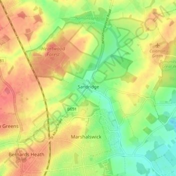
Name: Sandridge topographic map, elevation, terrain.
Location: Sandridge, St Albans, Hertfordshire, England, United Kingdom (51.75716 -0.33751 51.80346 -0.26699)
Average elevation: 344 ft
Minimum elevation: 240 ft
Maximum elevation: 440 ft
Make a donation
Gear up for your next adventure:
As an Amazon Associate, this site earns from qualifying purchases at no extra cost to you.
Other topographic maps
Click on a map to view its topography, its elevation and its terrain.
Colney Street
United Kingdom > England > Hertfordshire > St Albans > Frogmore
Average elevation: 256 ft
Tyttenhanger
United Kingdom > England > Hertfordshire > St Albans > Colney Heath
Average elevation: 272 ft