
Make a donation
Gear up for your next adventure:
As an Amazon Associate, this site earns from qualifying purchases at no extra cost to you.
Rennertshofen topographic map
Click on the map to display elevation.
Make a donation
Gear up for your next adventure:
As an Amazon Associate, this site earns from qualifying purchases at no extra cost to you.
Rennertshofen
Nach der amtlichen Statistik gab es 2017 in der Gemeinde 798 sozialversicherungspflichtige Arbeitsplätze; von der Wohnbevölkerung gingen 2073 Personen einer versicherungspflichtigen Tätigkeit nach. Die Zahl der Auspendler lag damit um 1275 höher als die der Einpendler. Arbeitslos waren 37 Einwohner.
Make a donation
Gear up for your next adventure:
As an Amazon Associate, this site earns from qualifying purchases at no extra cost to you.
About this map
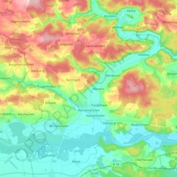
Name: Rennertshofen topographic map, elevation, terrain.
Average elevation: 1,480 ft
Minimum elevation: 1,247 ft
Maximum elevation: 1,890 ft
Make a donation
Gear up for your next adventure:
As an Amazon Associate, this site earns from qualifying purchases at no extra cost to you.
Other topographic maps
Click on a map to view its topography, its elevation and its terrain.
Pobenhausen
Deutschland > Bayern > Landkreis Neuburg-Schrobenhausen
Die Wallfahrt auf dem Kalvarienberg geht ersten urkundlichen Erwähnungen nach bis zurück ins Jahr 1764 und fand traditionell immer am Pfingstmontag einen ihrer Höhepunkte. Unterbrochen durch die Kriegsjahre wird hier auf dem heiligen Berg gefeiert. Mit Pater Rupert Mayer war 1933 auch ein inzwischen…
Average elevation: 1,273 ft
Sandizell
Deutschland > Bayern > Landkreis Neuburg-Schrobenhausen > Schrobenhausen
Average elevation: 1,358 ft
Make a donation
Gear up for your next adventure:
As an Amazon Associate, this site earns from qualifying purchases at no extra cost to you.
Ambach
Deutschland > Bayern > Landkreis Neuburg-Schrobenhausen
Ambach liegt nördlich von Ehekirchen auf den flachen tertiären Höhen der Aindlinger Terrassentreppe. Naturräumlich gehört es also zur Donau-Iller-Lech-Platte, die wiederum Teil des Alpenvorlandes ist, eine der Naturräumlichen Haupteinheiten Deutschlands. Der Ort Ambach liegt direkt westlich, der Kagerhof…
Average elevation: 1,414 ft
Make a donation
Gear up for your next adventure:
As an Amazon Associate, this site earns from qualifying purchases at no extra cost to you.
Hinterkaifeck
Deutschland > Bayern > Landkreis Neuburg-Schrobenhausen > Gröbern
Average elevation: 1,388 ft
Hörzhausen
Deutschland > Bayern > Landkreis Neuburg-Schrobenhausen > Schrobenhausen
Average elevation: 1,417 ft
Make a donation
Gear up for your next adventure:
As an Amazon Associate, this site earns from qualifying purchases at no extra cost to you.
Make a donation
Gear up for your next adventure:
As an Amazon Associate, this site earns from qualifying purchases at no extra cost to you.
Donau
Deutschland > Bayern > Landkreis Neuburg-Schrobenhausen > Neuburg an der Donau
Average elevation: 1,286 ft
Make a donation
Gear up for your next adventure:
As an Amazon Associate, this site earns from qualifying purchases at no extra cost to you.
Rödenhof
Deutschland > Bayern > Landkreis Neuburg-Schrobenhausen > Neuburg an der Donau
Average elevation: 1,247 ft
Kreut
Deutschland > Bayern > Landkreis Neuburg-Schrobenhausen > Oberhausen
Average elevation: 1,362 ft