
Make a donation
Gear up for your next adventure:
As an Amazon Associate, this site earns from qualifying purchases at no extra cost to you.
Meeuwen topographic map
Click on the map to display elevation.
Make a donation
Gear up for your next adventure:
As an Amazon Associate, this site earns from qualifying purchases at no extra cost to you.
Meeuwen
Meeuwen is gelegen op het Kempens Plateau. De hoogte bedraagt 56-82 meter.
Make a donation
Gear up for your next adventure:
As an Amazon Associate, this site earns from qualifying purchases at no extra cost to you.
About this map
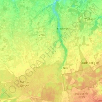
Name: Meeuwen topographic map, elevation, terrain.
Location: Meeuwen, Oudsbergen, Maaseik, Limburg, België (51.03331 5.45438 51.12293 5.54893)
Average elevation: 243 ft
Minimum elevation: 171 ft
Maximum elevation: 289 ft
Make a donation
Gear up for your next adventure:
As an Amazon Associate, this site earns from qualifying purchases at no extra cost to you.
Other topographic maps
Click on a map to view its topography, its elevation and its terrain.
Make a donation
Gear up for your next adventure:
As an Amazon Associate, this site earns from qualifying purchases at no extra cost to you.